
Dangerous 371mm Rain Hits Queensland as 2 Tropical Lows Threaten Coast
Dangerous 371mm Rain Hits Queensland as 2 Tropical Lows Threaten Coast
Event Status: Active Warning (Monsoon Trough & Tropical Lows)
As the calendar turns to early March, the Sunshine State is finding very little sun to celebrate. Instead, Queensland is bracing for a period of extreme weather that feels relentless, even by the standards of a northern Australian wet season. The current atmospheric setup is complex and high-stakes, as a massive burst of monsoon activity is currently fueling multiple weather threats simultaneously. Most notably, as the heavy Rain Hits Queensland, residents from the Cape York Peninsula down to the southeast corner are being told to prepare for a very wet and potentially dangerous week ahead.
🌧️ Tropical System & Rainfall Overview
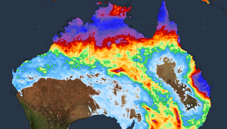
The primary driver of the current chaos is an active monsoon trough stretching across northern Australia. This trough is acting like a conveyor belt, funneling deep tropical moisture directly into the heart of the state. This intense Rain Hits Queensland with such frequency that the ground in many regions has reached a point of total saturation, meaning every new drop contributes immediately to runoff and rising river levels. Record Rainfall Totals (Last 24-48 Hours):
Gairloch, QLD: A staggering 371.2 mm was recorded recently, marking the highest weekly total at a Bureau gauge in the region. Hawkins Creek, QLD: This area saw 239.2 mm in just 24 hours, leading to immediate localized flooding. North Tropical Coast: Overnight, large sections of the coast were dumped with between 100mm and 300mm of rain.
Jonathan Howe from the Bureau of Meteorology (BOM) has noted that we are now in an exceptionally active monsoon period. This isn’t just a localized shower; it is a broad-scale event. As this relentless Rain Hits Queensland, the risk of flash flooding becomes a minute-by-minute concern for emergency services.
🌀 The “Cyclone Sandwich” Threat
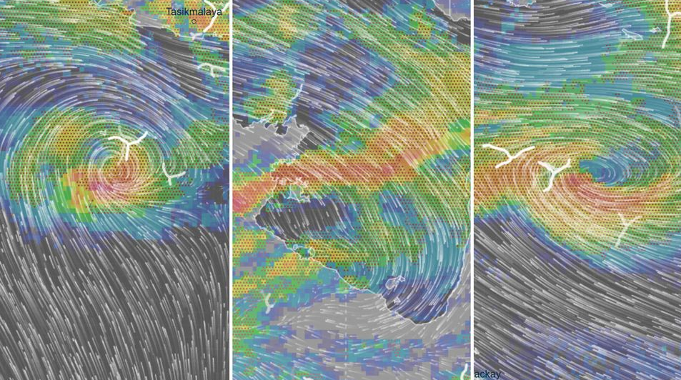
The most concerning development is what meteorologists are calling a “cyclone sandwich.” The Cape York Peninsula is currently caught between two developing tropical lows, both of which have the potential to intensify into named tropical cyclones. Tropical Low 29U: Currently sitting over the Coral Sea, this system is approximately 1,000 km east of Cairns.
While its development chance was initially low, the BOM has upgraded its outlook to a 25 per cent chance of becoming a tropical cyclone by Thursday or Friday. It is projected to track southwest, potentially crossing the coast between Cooktown and Townsville on Friday. Tropical Low 31U: This system has formed in the Gulf of Carpentaria.
It currently has a 10 to 15 per cent chance of becoming a cyclone as it moves west toward the Northern Territory. Regardless of whether these systems officially reach cyclone status, the moisture they drag with them ensures that more heavy Rain Hits Queensland throughout the week. If they do intensify, the next names on the Australian list are Narelle, Oran, Peta, and Riordan.
This season has already been prolific, with nine cyclones already having formed since November.⚠️ Flood Warnings & Regional Impacts.
The impact of this moisture is most visible in the state’s river systems. A Major Flood Warning has been issued for the Herbert River following the massive overnight totals.
Further north, the Daintree River is under a Minor Flood Warning as water levels continue to creep up. The forecast for the coming days suggests that isolated falls of an additional 200mm to 300mm are likely. When this volume of Rain Hits Queensland in such a short window, the infrastructure is pushed to its absolute limit.
Ben Domensino from Weatherzone warns that some computer models suggest at least one of these eastern systems will drag that heavy moisture all the way down into central and southeast Queensland by the end of the week.🏥 Safety & Infrastructure Notes
The human cost of these weather events is often measured in disruption and isolation. Widespread road closures are currently in effect across western and northern parts of the state. As the Rain Hits Queensland, many inland towns are finding themselves cut off as river crossings become impassable.
Agriculture: Farmers in the Gulf and Cape York regions are facing a nightmare scenario for livestock management. Power & Utilities: Damaging wind gusts of up to 90 km/h are expected along the coast, which could lead to significant power outages as trees fall on lines. The message from authorities is clear: if it’s flooded, forget it.📉 Strategic Analysis of the System
This season has been unusually active, and the frequency with which the Rain Hits Queensland has left little time for recovery between events. The combination of high sea surface temperatures and the active monsoon trough means the atmosphere is primed for these “tropical lows” to behave unpredictably.
Meteorologists are keeping a close watch on the “deep moisture” being pulled from the tropics. Even if 29U remains a tropical low, its ability to act as a “moisture pump” is significant. As this Rain Hits Queensland, we could see coastal inundation and large waves affecting the Whitsundays and the Townsville coast, making beach conditions extremely hazardous.🤝 Community Preparedness
In communities like Port Douglas, Cairns, and Mackay, locals are already sandbagging and securing loose items. The cumulative effect of the season means that even a “minor” storm can have major consequences.
🔚 Conclusion: Watching the Skies
The coming 48 to 72 hours will be critical. Whether we see the birth of Cyclone Narelle or simply a very powerful tropical low, the result is the same: massive amounts of water moving through the landscape. As this intense Rain Hits Queensland, the priority remains the safety of life and property. The state is used to big wet seasons, but the “relentless” nature of this March event is something that requires the utmost caution.